
Linking SVRGIS with FEMA Disaster Declarations and Census/ACS

Linking SVRGIS with FEMA Disaster Declarations and Census/ACS

Link to code

Click here

Author/Creator: Amy Read

Specific purpose of code: This code provides examples of how to pull, filter, and merge data from the NOAA/NWS Severe Weather GIS Database (SVRGIS), OpenFEMA Disaster Declarations Summaries, and data from the Decennial Census and American Community Survey (ACS). Walkthroughs are provided for A) merging FEMA disaster declarations to SVRGIS tornado paths data based on incident date and location, B) performing a spatial join between event paths and Census geographies (intersection of line and polygon) to identify geographic areas that were exposed to tornadoes, hail, and/or wind during the user-specified timeframe.

General Application: This template can be extended to access and merge other OpenFEMA datasets based on incident (such as Public Assistance or Individual Assistance summary data), and any other data on Census geographic boundaries that is of interest to the researcher. This code also allows the user to identify FEMA disaster declarations for tornado events at smaller geographic levels (tracts, block groups, etc.).

How does or could this code allow researchers to assess research questions related  to aging or life course?: This code could be used with any of the ACS/Census data subset by age group. Since this code focuses on the spatial join between tornado/wind/hail event paths and Census geographies, any other demographic/health datasets tracked by state, county, tract, block group, etc. could be merged by FIPS code into these data the same way one would combine them with Census data alone.

Data sets used: 

  • Population, socioeconomic, or health data: Decennial Census, ACS
  • Climate, weather, disaster or environment data: SVRGIS (Tornadoes, Wind, Hail) and FEMA Disaster Declarations Summaries

Are all the data publicly available or are some restricted-access? All are publicly available.  

Links to data:

Coding Language:  R 

Tools and Packages used: tidycensus, rfema, sf, tidyverse

Output(s): Merged dataset saved to .Rds format

Spatial extent: Contiguous United States

Temporal extent: Example focuses on 2000-2010 but explains how to filter/extend beyond that. SVRGIS data is available from 1950 for tornadoes and from 1955 for hail and wind. FEMA disaster declarations are available from 1953. 

Comments: This is a revised, streamlined, and more generalized version of the code used for the manuscript below. That code is also available on the author’s GitHub.

Published papers that use this code: Read, A. (2025). Repeated disaster and the economic valuation of place: Temporal dynamics of tornado effects on housing prices in the United States, 1980–2010. Population and Environment, 47(3), 29. https://doi.org/10.1007/s11111-025-00502-w

Continue reading

Weathering the Impact: ENSO-Driven Disasters, Power Disruption, and Health Outcomes in Medicare Populations

Weathering the Impact: ENSO-Driven Disasters, Power Disruption, and Health Outcomes in Medicare Populations


Investigators:

Sara Curran, Jeff Stanaway, Luanne Thompson, June Yang, Emmanuela Gakidou

Data sources:

ENSO indices from the National Oceanic and Atmospheric Administration Climate Prediction Center from 1980-2025.

SHELDUS: Special hazard events and losses database for the United States 1970 – 2023. Available by County and day.

Center for Medicare & Medicaid Services claim and beneficiary data from 1990-2023. Available by County and day.

HHS emPOWER: Count of medicare beneficiaries who rely on electricity-dependent durable medical and assistive equipment and devices from 2016-2025. Available by County and month.

DOE-417 archive data: Electric Emergency Incident and Disturbance Report from 2000 to 2023. Available by County and Day.

Spatial Coverage: United States

Temporal Coverage: 2016 – 2023.

Measures:

  • Climate Measurements:

    • ENSO Indices (NOAA): Seasonal measurements of sea surface temperature anomalies used to classify El Niño and La Niña events.
    • SHELDUS: Provides detailed records of natural disaster events (including type, date, and location), allowing alignment of local disasters with ENSO periods. It also includes loss data (e.g., property damage, crop loss, injuries) to quantify event severity.

    Power Infrastructure Measurements:

    • HHS emPOWER Dataset: Monthly, county-level counts of Medicare beneficiaries who rely on electricity-dependent durable medical equipment (DME), indicating vulnerability to power disruptions.
    • DOE OE-417 Archive: Incident-level reports on electrical disturbances, including type of event, date/time, geographic area, and population affected.

    Health Outcomes:

    • CMS Claims and Quality Measures: Data on Medicare beneficiaries covering:
      • Hospital readmission rates
      • Emergency department (ED) and inpatient utilization
      • Home health services
      • Minimum Data Set (MDS) indicators from nursing homes
      • Preventable hospitalizations (e.g., ambulatory care-sensitive conditions)

    Demographic and Socioeconomic Context:

    • County-Level Medicare Population Characteristics: Including race/ethnicity, age, sex, and dual eligibility for Medicare and Medicaid, enabling analysis of differential impacts across vulnerable groups.

Project Summary:

Disruptions driven by the El Niño-Southern Oscillation (ENSO), such as flooding, drought, and extreme temperatures, have long been implicated in public health threats across the United States. For example, during negative phases of ENSO (La Nina events) there is typically an increase in the number of hurricanes that can result in major floods. This also occurs during El Nino events in the Southwest US.  Major floods have been shown to elevate hospitalization rates among older adults for skin conditions, neurological illnesses, musculoskeletal disorders, and injuries in the weeks following exposure (Aggarwal et al. 2025). In addition, other impacts include health care disruptions due to displacement from homes and communities or through damage to health infrastructure. These might be particularly important for those requiring frequent care for chronic illnesses.

However,  mechanisms linking ENSO-related disasters with health outcomes remains poorly understood. For instance, the role of power infrastructure failure, such as prolonged outages disrupting electricity-dependent medical care is a plausible pathway for detrimental impacts on healthcare particularly for the elderly who are less mobile than the general population..

Our U.S.-based project investigates how ENSO-related disasters influence health outcomes among older adults, focusing especially on power disruptions as a critical explanatory pathway. By aligning the data sources mentioned above, we aim to trace if and how power outages amplify the health impact of ENSO-driven disasters on older adults.

We will employ a combination of panel regression models, Difference-in-Difference analysis, and causal mediation analysis to estimate the direct and indirect effects of ENSO-driven disasters, to quantify the role of infrastructure failure and identify populations at higher risk.

Comments

Papers on impacts of El Nino in the U.S. 

Outputs:

Peer-reviewed publications, grant proposals, conference presentations

References:

Aggarwal, Sarika, Jie K. Hu, Jonathan A. Sullivan, Robbie M. Parks, and Rachel C. Nethery. 2025. “Severe Flooding and Cause-Specific Hospitalisation among Older Adults in the USA: A Retrospective Matched Cohort Analysis.” The Lancet Planetary Health 9(7):101268. doi:10.1016/S2542-5196(25)00132-9.

Fussell, Elizabeth, Sara R. Curran, Matthew D. Dunbar, Michael A. Babb, Luanne Thompson, and Jacqueline Meijer-Irons. 2017. “Weather-Related Hazards and Population Change: A Study of Hurricanes and Tropical Storms in the United States, 1980–2012.” The ANNALS of the American Academy of Political and Social Science 669(1):146–67. doi:10.1177/0002716216682942.

Salas, Renee N., Laura G. Burke, Jessica Phelan, Gregory A. Wellenius, E. John Orav, and Ashish K. Jha. 2024. “Impact of Extreme Weather Events on Healthcare Utilization and Mortality in the United States.” Nature Medicine 30(4):1118–26. doi:10.1038/s41591-024-02833-x.

Continue reading

What Am I Reading: Disasters and Aging in Place

What am I reading? Disasters and Aging in Place

Link to article

If you’re interested in contributing a short What Am I Reading post, we’d love to hear from you! Email us at cache@colorado.edu

Written by Jenna Tipaldo, CUNY School of Public Health and CUNY Institute for Demographic Research, jenna.tipaldo09@sphmail.cuny.edu

A new report from Winkler & Mockrin (2025) entitled “Aging and wildfire risk to communities” explores the exposure of older populations to wildfires. A main findings is that “Nearly all (87 percent) of the population growth in higher wildfire risk locations between 2010 and 2020 was among people over the age of 60, many of whom had been living in higher risk places for years and are growing older (i.e., aging in place).” Each is relevant when thinking about older adults and exposure, vulnerability, and resilience to disasters.  Wildfires are just one of type of disaster to consider: recent evidence also suggests that coastal zones – areas at risk of storms and other seaward hazards such as flooding and tsunamis – are also aging faster than areas farther inland (Bukvic et al., 2018; Hauer et al., 2020; Tagtachian and Balk, 2023). 

No relocation: Forsyth & Molinsky (2020) note that to some, aging in place signifies remaining in their home while to others it may mean moving but within the same community, such as downsizing. Based on recent shifts in age distribution in Census blocks with “moderate-to-high” wildfire risk, Winkler & Mockrin (2025) conclude that the increase in older adult populations in fire-prone regions is likely attributable to populations aging in place rather than in-migration (Figure 4). They also note important spatial variation and also uncertainty about the relative contributions of migration and death. They also note that aging in place seems to be the “primary mechanism” in higher risk rural areas (Winkler & Mockrin, 2025). 

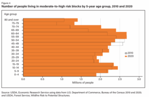
Source: Winkler & Mockrin (2025)

Health and Health Care : Winkler & Mockrin (2025) summarize the various ways in which older adults can be at higher risk due to wildfires including 1) physical limitations that are barriers to preparation or response, 2) factors like social isolation which can impact access to information and resources, and 3) higher rates of chronic diseases which are risk factors for adverse health outcomes due to fires and smoke. Furthermore, disasters can be disruptive to healthcare, not only by damaging facilities and displacing people from their homes but also by disrupting care which relies on movement. Examples include when patients are unable to travel to hospitals or medical providers, or if healthcare workers can‘t get to a patient’s home due to inaccessible roads (Tarabochia‐Gast et al., 2022) or suspended public transit systems. Rural areas face additional challenges with longer travel times for healthcare access, especially with high levels of hospital closures (Miler et al., 2020; McCarthy et al., 2021). Such patterns negatively impact health care access, emergency medical response, and transport times (GAO, 2021; Kaufman et al., 2016). On average, rural residents must travel about 20 miles farther for typical health care services – in non-disaster times (GAO 2021). While those miles may seem trivial, in emergencies they can mean loss of access to care and treatment. 

Personal choice: Aging in place can be a personal choice in support of maintaining one’s agency and independence by staying in one’s own home and community (Forsyth & Molinsky, 2020). Even so, staying in one’s home can also result from lack of choice due to limited resources and/or few desirable and affordable options. Modifications are expensive too. Even older adults who are relatively better off can struggle to pay for downsizing or modifying a new dwelling for care needs (Forsyth & Molinsky, 2020).  

From research to policy 

To help support healthy aging in place, Winkler & Mockrin (2025) suggest that existing programs that support older adults could be expanded to include wildfire risk reduction. An example is the USDA’s Section 504 Home Repair program which supports older low-income homeowners. In addition, organizations such as the AARP provide useful material for aging in place such as a checklist for people who are prepping their home. Such resources should be expanded to include disaster risk as a consideration.  


References:  

  • Bukvic, A., Gohlke, J., Borate, A., and Suggs, J. 2018. “Aging in Flood-Prone Coastal Areas: Discerning the Health and Well-Being Risk for Older Residents.” International Journal of Environmental Research and Public Health 15(12):2900. https://doi.org/10.3390/ijerph15122900.   
  • Hauer, Mathew E., Elizabeth Fussell, Valerie Mueller, Maxine Burkett, Maia Call, Kali Abel, Robert McLeman, and David Wrathall. 2020. “Sea-Level Rise and Human Migration.” Nature Reviews Earth & Environment 1(1):28–39. https://doi.org/10.1038/s43017-019-0002-9 
  • Kaufman, B.G., Thomas, S.R., Randolph, R.K., et al. The rising rate of rural hospital closures. The Journal of Rural Health. 2016;32(1):35-43. https://doi.org/10.1111/jrh.12128  
  • McCarthy, S., Moore, D., Smedley, W. A., Crowley, B. M., Stephens, S. W., Griffin, R. L., Tanner, L. C., & Jansen, J. O. (2021). Impact of Rural Hospital Closures on Health-Care Access. Journal of Surgical Research, 258, 170–178. https://doi.org/10.1016/j.jss.2020.08.055 
  • Miller, K.E.M., James, H.J., Holmes, G.M., Van Houtven, C.H. The effect of rural hospital closures on emergency medical service response and transport times. Health Serv Res. 2020;55(2):288-300. https://doi.org/10.1111/1475-6773.13254  
  • Tagtachian, D. and Balk, D., 2023. Uneven vulnerability: characterizing population composition and change in the low elevation coastal zone in the United States with a climate justice lens, 1990–2020. Frontiers in Environmental Science, 11, p.1111856. 
  • Tarabochia‐Gast, A. T., Michanowicz, D. R., & Bernstein, A. S. (2022). Flood Risk to Hospitals on the United States Atlantic and Gulf Coasts From Hurricanes and Sea Level Rise. GeoHealth, 6(10), e2022GH000651. https://doi.org/10.1029/2022GH000651 
  • Winkler, R. L., & Mockrin, M. H. (2025). Aging and wildfire risk to communities (Report No. EIB-284). U.S. Department of Agriculture, Economic Research Service. https://doi.org/10.32747/2025.9015828.ers 


Continue reading

US Census Bureau Household Pulse Survey – Disaster Displacement

US Census Bureau Household Pulse Survey – Disaster Displacement

Link to code

Click here

Authors/Creators/ Team Members: Ther W. Aung, Ashwini R. Sehgal

Specific purpose of code: The purpose of this code is to analyze the questions regarding displacement due to disasters in US Census Bureau’s Household Pulse Survey. The code is applied to a single dataset.

General Application: This code is an example of analyzing nationally-representative survey data using weights and replicate weights.

How does or could this code allow researchers to assess research questions related  to aging or life course?: This code could be used or applied to analyze nationally-representative survey data, which tend to have age as a variable and may either span the entire population or target a particular demographic. The Household Pulse Survey has participants aged 18 and above, with age top-coded at 88 (age is calculated by subtracting year of birth from the survey year).

Data sets used: 

Coding Language: Stata

Tools and Packages used: svyset, svy

Output(s): Dataset, tables, multivariate covariates of displacement and collinearity assessment

Spatial extent: US

Temporal extent: 2022-2023

Published papers that use this code: Aung, T. W., & Sehgal, A. R. (2025). Prevalence, Correlates, and Impacts of Displacement Because of Natural Disasters in the United States From 2022 to 2023. American Journal of Public Health, 115(1), 55–65. https://doi.org/10.2105/AJPH.2024.307854

Related Papers: Depression and Anxiety Symptoms in Adults Displaced by Natural Disasters

Continue reading

Federal Emergency Management Agency (FEMA) Multi-Faceted, Publicly-Available Disaster Data Platform

The multi-faceted, publicly-available disaster data platform from the Federal Emergency Management Agency (FEMA)

About:

OpenFEMA is the “agency’s data delivery platform which provides datasets to the public in open, industry standard, machine-readable formats. Datasets are available in multiple formats, including downloadable files and through an easily digestible Application Programming Interface (API). Each page includes information about the specific dataset, links to downloadable files, a data dictionary describing each field, and an endpoint link (if applicable for those datasets available via the API).”

Data are available on:

Disasters: declaration denials; disaster declaration summaries; FEMA web declarations; FEMA web disaster declarations; FEMA web disaster summaries; mission assignments.

Emergency management: annual NRIRS public data (National Fire Incidence Reporting System); emergency management performance grants; IPAWS archived alerts; national household survey; non-disaster and assistance to firefighter grants; Disaster Relief Appropriations Act of 2013 (Hurricane Sandy)

Individual assistance: FEMA assists individuals and households through the coordination and delivery of Individual Assistance (IA) programs. IA includes a number of programs, including the Individuals and Households Program (IHP) which is comprised of Housing Assistance (HA) and Other Needs Assistance (ONA). 

  • Data include: housing assistance program data (owners and renters); large disasters registration intake and household program.

Public assistance: Public Assistance (PA) is FEMA’s largest grant program providing funds to assist communities responding to and recovering from major declared disasters or emergencies.

  • Data include: Public Assistance Applicants; Public Assistance Applicants Program Deliveries; Funded Project Details; Funded Projects Summaries; Grant Award Activities; Second Appeals Tracker

Hazard mitigation: Hazard Mitigation Assistance (HMA) is for actions taken to reduce or eliminate long term risk to people and property from natural disasters.

  • Data include: Assistance Mitigated Properties; projects; grant program; disaster summaries; mitigation plan statuses, communities; transactions; and more

National Flood Insurance Program (NFIP) aims to reduce the impact of flooding on private and public structures.

  • Data include: NFIP reinsurance placement information; community layer; redacted claims and policies; status

Misc

  • FEMA regions; Datasets; Fields

Continue reading